Ride Leader Kit

For cycling club ride leaders

Plan the ride.
Lead the group.

Ride Leader Kit checks the route, the weather and the stops before you say “see you Sunday”, then gives everyone the same page. Nobody asks where the café is. Nobody gets left behind.

No password and nothing to install. We email you a sign-in link.
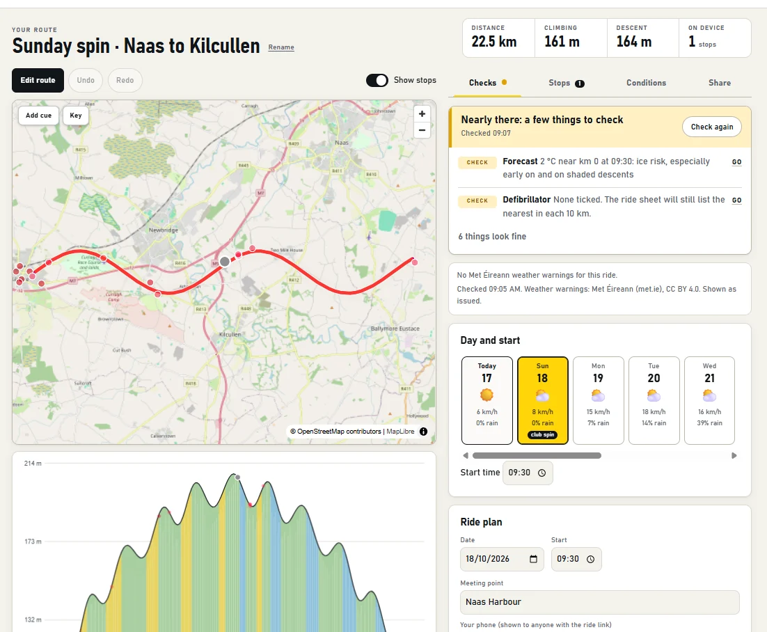
A 22 km Sunday spin on the map with its elevation profile, a Ready to ride card flagging an ice risk at 9:30, and a five-day forecast.

“Is it still on? Where do we stop? Is the café even open?”

That is a lot to hold in your head and a WhatsApp thread. Ride Leader Kit answers it from the route itself, and tells you plainly when it can’t.

What it checks along your route

The things a good leader checks, done before you leave the house.

  • Weather warningsMet Éireann warnings for the counties you ride through, shown as issued, plus the forecast hour by hour at each point on the route.
  • DaylightSunset against your pace group’s finish time, so a late start in October doesn’t become a ride home in the dark.
  • Closures and roadworksRoads marked closed or private along the line, counted only where the route really runs along them.
  • Café hours against your ETAOpen, closed or unknown at the time each group arrives. About one café in four has hours on the map; the rest say Unknown. We never guess.
  • Defibrillators and servicesThe nearest defibrillator in every 10 km, plus cafés, water and bike shops, ready to tick for the ride sheet.
  • Climbs and regroupsEvery real climb with its gradient, and suggested regroup points at the top, so the slower group is never chasing.

It prompts. You decide. Ride Leader Kit helps you do the checks leaders are taught. It doesn’t replace a recce or your own risk assessment, and it never says a ride is “safe”.

One page for the whole group

Everyone on the same page.
Literally.

The ride sheet is a light page that opens on any phone, no app and no account. The WhatsApp text and the A5 cue card come from the same plan, so what you say and what you hand out always match.

  • Start time, meeting point and your phone number
  • Pace groups with estimated arrival at each stop
  • Where the defibrillators and cafés are
  • Weather and warnings as of this morning
Sunday 18 October · 09:30Naas to Kilcullen22.5 km · Naas Harbour
A word from the leader

Mudguards on, please, it’ll be wet underfoot. We regroup at every stop and nobody gets left behind.

A28 km/hKilcullen 10:14
B24 km/hKilcullen 10:21
C20 km/hKilcullen 10:32

From route to ride sheet

Three steps, about as long as a coffee.

  1. 1Bring a route

    Drop in a GPX file, or pull a route straight from Strava. Fix it on the map if you want to, and add your own cues with a right-click.

  2. 2Check it

    The Ready to ride card lists what needs a look and what is fine. Anything it can’t know is marked unknown, never green.

  3. 3Share it

    Send the link, paste the WhatsApp text, print the cue card, or send the finished route back to your head unit.

Works with what you already use

Your club platform stays. This is the planning step.

Ride Leader Kit doesn’t manage members or take bookings. Plan the ride here, then publish it wherever your club does. For Cyql there is a ready-made panel that copies each field of the ride form, with the GPX and the description.

  • Strava routes
  • GPX files
  • Garmin
  • Wahoo
  • Hammerhead Karoo
  • Cyql
  • WhatsApp
  • Printed cue cards

Private by default

Your routes are yours.

You choose who sees a ride

Nothing is public until you share its link. Strava routes are only ever shown to the person who owns them.

Delete it all in one click

Remove your account and every route and ride with it, from the account page. We email you a confirmation.

No ads, no tracking of riders

The ride sheet loads no scripts at all. The map data is OpenStreetMap, the warnings are Met Éireann’s.

Questions leaders ask

Straight answers.

Does it replace my risk assessment or the recce?

No. It makes the checks quicker and harder to forget, and the leader still decides. It will not tell you a ride is safe.

Does it work outside Ireland?

The routing, stops, daylight and forecast work anywhere OpenStreetMap does. The official weather warnings come from Met Éireann, so they cover Ireland only.

Does my club need to switch from Cyql or WhatsApp?

No. Plan here, then post the plan wherever your club already talks.

What if the data is wrong?

Map data is crowd-sourced, so sometimes it is. A closure can be stale and a café may have changed its hours. That is why unknowns are marked and why the route is checked against the map you can see.

What does it cost?

It is free while we pilot it with clubs.

Before you say “see you Sunday”.

Plan a ride

Questions? Read how we handle your data.

How Ride Leader Kit works

Plan a club ride from a route file, check the café and the weather, and put the stops on your head unit. Each section opens on its own.

Planning a ride in five steps
  1. Get a route in. Upload a GPX file from the home page, or connect Strava and import one of your routes.
  2. Pick the day and start time. The strip under the map shows the forecast for the next days. Weekends and your club's usual day are marked.
  3. Find stops. Press Find stops along route for cafés, water, toilets, defibrillators, service stations and historic sites near the line.
  4. Choose what goes on the device. Tick a stop to include it in the export. Faded dots on the map are candidates; solid dots are ticked.
  5. Export or share. Use Export… for Garmin, Wahoo, Karoo or a plain GPX, and the ride sheet for the group.
The “Ready to ride?” card

The card at the top of a route gathers what a leader checks before saying the ride is on: the day, meeting point, weather warnings, forecast, daylight, closures, the stops going on the device and whether the cafés are open when the group arrives. Fix means something is wrong, Check means look at it, Unknown means we couldn't check (that is never the same as fine). Press Go to jump to the part of the page that fixes it. The tools beside the map are in four tabs: Checks, Stops, Conditions and Share. On a phone, the bar along the bottom opens Stops, Export and Share.

Bringing in a route (GPX or Strava)

GPX. Any track from a bike computer, Komoot, RideWithGPS or similar. Routes you upload are private to you.

Strava. Connecting gives this app read-only access to your routes; it can't change anything on Strava. Private routes need the extra permission Strava asks about when you connect. Imported routes are visible only to you and are deleted automatically after 7 days, or straight away if you disconnect. To share one with the club, use Share a copy with your club on the route page, which makes a separate copy you own.

Getting cues back onto Strava. Strava lets apps read routes but not create or edit them. On an imported route, Send cues back to Strava… gives you a GPX with your ticked cues to upload on Strava yourself. Strava decides which cues it keeps; they all stay in the file for your head unit.

Finding and choosing stops
  • Search distances (under the button) say how far from the line to look for each kind of stop.
  • Open a group in the list to see its stops. Select all and Clear work on one group at a time.
  • For cafés, Only open on arrival keeps those that will be open when the group gets there. Hours come from OpenStreetMap or from the club's own corrections; set your own with the clock button.
  • The cup button marks a café as a planned group stop, so later arrival times allow for the break.
  • Pin a stop to keep it through later searches. Delete removes it.
  • Use Show stops on the map above the map to hide the dots when you want a clear view of the route.

Stops come from OpenStreetMap volunteers, so a place can be missing, moved or closed. Check anything that matters before you rely on it.

Adding your own cues on the map

Right-click the map where you want a cue (on a phone, press and hold). Pick a type: Left, Right, Straight, Danger, Water, Food, First aid, Toilets, Summit, Valley, Sprint or Generic. Give it a name and an optional note, then Add cue. There is also an Add cue button on the map that uses the middle of the view.

  • The cue snaps to the nearest point on the route and is ticked for export straight away.
  • It must be within 3 km of the route. The menu shows how far from the line you clicked.
  • On Garmin and Wahoo, turn cues appear as course points with an alert. On Karoo and some other devices they appear as plain points.
  • Mistake? Delete it from the stops list.
Editing the route

Press Edit route. Drag the line to move that stretch onto different roads, or tap the map to pull the route through a point. Drag a numbered point to move it, or tap it to remove it. Only the stretch you change is re-routed, and the rest of your file is left exactly as it was.

Edits stay on your own line: where the router's new path simply retraces your original, your original points are kept, so only the stretch that truly differs changes. Prefer quieter roads is off by default, because it can move a reroute onto side roads beside the one you chose; turn it on if that is what you want. Undo and Redo step through your changes.

Reading the elevation profile

The profile sits under the map and is coloured by gradient: blues are descents, green is flat, then yellow, orange and red as it gets steeper. Move your pointer along it to see distance, height and gradient, and a marker follows on the map. Shaded bands show detected climbs. The strip under the axis shows head, cross and tail wind when a forecast is available.

Weather, warnings and daylight

Forecasts are from Met Éireann, with Open-Meteo as a fallback. Weather warnings are shown exactly as Met Éireann issues them. If the warnings can't be fetched the page says so; that is not the same as "no warnings", so check the official page before you ride.

Road closures and hazards

Closures come from the club's own entries and from roadworks mapped in OpenStreetMap. Irish councils and Transport Infrastructure Ireland don't publish a feed we can use, so a clear result is not proof the road is open. Hazards such as cattle grids, fords and level crossings are flagged from map data.

Exporting to your device

Choose your device on the export page and follow the steps shown there. The same stops are written in the format each device understands.

Device behaviour changes with firmware. If a stop doesn't show, try the plain GPX export.

Sharing the ride sheet

The ride sheet has the meeting point, times for each pace group, stops, climbs, weather and emergency details on one page. Turn on a share link to send it to the group; anyone with the link can see it, including the phone number you entered, and you can switch the link off at any time. Copy summary for WhatsApp gives you a short text version, and Cue card (PDF) prints on A5 for a jersey pocket. Routes imported from Strava can't be shared this way.

Your data

Download or delete everything we hold about you from your account page. Disconnecting Strava removes its data immediately. Read the privacy policy, or contact the Data Protection Commission if you have a complaint.

In an emergency call 112 or 999. Defibrillator locations come from OpenStreetMap and may be incomplete or out of date.

Map data © OpenStreetMap contributors. Weather: Met Éireann and Open-Meteo.